The Blair County Conservation District has been cooperating with the Capital RC&D to conduct Transect Surveys of the County since 2012. The purpose of the survey is to evaluate progress in reaching County and Statewide sediment reduction goals, and to provide accurate data on the adoption and use of conservation tillage systems. The survey looks at tillage practices, cover crops, and land use at pre-established points on a pre-determined route. The data collected is crop type, percent crop residue, land use, cover crop and cover crop planting method. Usually, the survey is conducted every 2-3 years and is done in the fall, with a follow-up completed in the spring.
The survey consists of driving a designated route and stopping at the designated points, approximately every 0.2 of a mile. The original Blair County route was 117.4 miles long with 509 points. However, some of the route has been changed due to loss of farmland to residential development. The route winds through Morrison’s Cove, up and down Clover Creek and Piney Creek, then through Catharine Township, Sinking Valley, Scotch Valley and Turkey Valley.
Over the years, we have observed an increase in the use of no-till planting and cover crops. Initially, cover crops were planted on corn fields taken off for silage. More recently, we are observing the planting of cover crops on later harvested crops such as corn for grain and soybeans. The most recent survey was conducted in the fall of 2020. Field observations were that more fields were cover cropped than ever before and fewer fields were conventionally tilled.
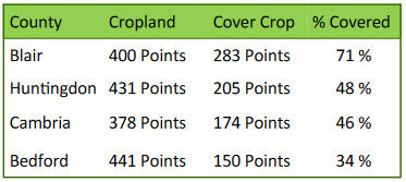
The 2020 Survey results are in and Blair County shows significant cover crop usage. Blair County stands at 71% of the points collected showed some form of “cover.” Research has shown that cover crops reduce erosion, limit nutrient pollution and have additional benefits of improving soil health and water quality!

The Tillage and Cover Crop Survey is being reported for inclusion in the State’s Watershed Implementation Plan (WIP).


